• Designated
Development - Environmental Planning
and Assessment Regulation 2000 The development is designated development under Schedule 3 of
the Environmental Planning and Assessment Regulation 2000
(EP&AReg) and as such should be accompanied by an Environmental
Impact Study (EIS) and should have been advertised in a local paper.
• Bushfire Risk -
Council resolution of 12 March 2002
The development poses an unacceptable risk in the event of bushfire,
most notably in that egress does not comply with Planning for Bushfire
Prevention 2001 (PfBP).
• Not in keeping
with land uses in area
The DA is not in keeping with the current land use in the area and it
impinges on our use of our land. In fact the plan places an effluent
disposal area and the APZ on our land.
• Sydney Regional
Environmental Plan No 20 The DA fails to meet obligations under the Sydney Regional
Environmental Plan No. 20 - Hawkesbury-Nepean River (No 2 - 1997).
• Hawkesbury Local
Environmental Plan 1989 and
Amendment 108
The DA does not meet the objectives of the Hawkesbury Local Environment
Plan 1989 for zone 7(d) Environmental Protection - Scenic or of
Amendment 108 for zone Environmental Protection - Mixed Agriculture.
• Clearing requires
consent of Minister under the
Native Vegetation Act 2003
The forests that make up the two endangered ecological communities
identified at this site are “remnant native
vegetation” under the Native Vegetation Act 2003 and so any
proposed clearing requires consent of the Minister.
• Traffic Risk
The access from Greens Rd is near a blind corner with inadequate sight
distances in both directions constituting an unacceptable risk. The
Traffic Impact Assessment also contains inaccuracies.
• The Waste Management Plan is missing
Despite being listed as an attachment to the DA, there is no Waste
Management Plan. Due to the sensitive nature of the local environment
this would seem an essential consideration.
• Traffic
Risk
The access from Greens Rd is near a blind corner with inadequate sight
distances in both directions constituting an unacceptable risk.
• The Waste Management Plan is missing
Despite being listed as an attachment to the DA, there is no Waste
Management Plan •Draft
Hawkesbury Local Environmental Plan
1989 Amendment 108 Inconsistent with objectives of zone Environmental Protection
- Mixed Agriculture.
Details
of above objections
DA0439/05
Tourist Facility
Designated
Development
This development application is for designated development as specified
in Schedule 3 of the Environmental Planning and Assessment Regulation
2000 (EP&AReg) and so should be accompanied by an Environmental
Impact Statement (EIS) and be subject to other conditions for
designated development set out in the EP&AReg such as
advertising in a local paper. Since the development application is not
accompanied by an EIS it is incomplete and so should be rejected by
Council.
This is designated development because Schedule 3 of the
EP&AReg describes designated development as follows:
Schedule 3 – Designated development
...
29 Sewerage systems or works
...
(4) Sewerage systems or works that release or reuse more than 20
persons equivalent capacity or 6 kilolitres per day of sewage, effluent
or sludge and that are located:
(a) in or within 100 metres of a natural waterbody, wetland, coastal
dune field or environmentally sensitive area, or
(b) in an area of high watertable, highly permeable soils or acid
sulphate, sodic or saline soils, or
(c) on land that slopes at more than 6 degrees to the horizontal, or
(d) within a drinking water catchment, or
(e) within a catchment of an estuary where the entrance to the sea is
intermittently open, or
(f) on a floodplain, or
(g) within 500 metres of a residential zone or 250 metres of a dwelling
not associated with the development.
The development application claims:
“1.4 Objectives
The proposal of wastewater is ancillary to the purpose of a subdivision
and the provision of Schedule 3 of the Environmental Planning and
Assessment Act (1979), probably do not apply. Nonetheless, the Sewerage
Treatment Plant for the proposed development is located more than 250m
from the house not involved in the development.”
However the EP&AReg which I assume this refers to (Schedule 3
of the Environmental Planning and Assessment Act 1979 (EP&AAct)
is unrelated), clearly refers to “sewerage systems or
works” and does not draw a distinction between the treatment
plant and the system or works. Therefore the entire system including
the effluent disposal area is covered by the regulation.
The “sewerage system or works” is in fact located
within 250m of at least two houses not associated with the development,
within 100m of a natural waterbody and is on land that slopes more than
6 degrees from the horizontal. The relevant measurements are:
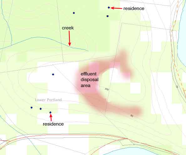
• Our house at 39 Greens Rd (Lot 1 in DP 593165) is 165m
from the effluent disposal area (measured from “Visual
Privacy/Adjoining Neighbours Plan” and from Department of
Lands Geospatial Portal Map).
• The house at 199 Greens Rd (DP 771370 RL 80) is 215m
from the effluent area (measured from “Visual
Privacy/Adjoining Neighbours Plan” and from Department of
Lands Geospatial Portal Map).
• The creek to the north of the development site constitutes a
natural water body (for the purposes of the EP&AR
“natural waterbody” is defined as including
“a river or stream, whether perennial or intermittent,
flowing in a natural channel with an established bed or in a natural
channel artificially modifying the course of the stream”.
This creek is only 60m from the disposal area
(measured from Department of Lands Geospatial Portal Map).
Geospatial Portal Map showing location of creek relative to development
site
• The land slopes more than 8.5 degrees
from horizontal (Section 2.4 of the Watercycle Study states
“The existing slope of the proposed disposal area is a
maximum of 15%” which is more than 8.5 degrees and this can
also be measured from the map labelled Figure 3).
This gives at least 4 reasons why this is designated development.
The claim in the DA that ”The proposal of wastewater is
ancillary to the purpose of a subdivision” makes no sense in
reference to either this development application or the
EP&AReg. In fact Schedule 3 of the EP&AReg makes no
reference to subdivisions at all. We have obtained a legal opinion from
the Environmental Defenders Office on this matter and they have
confirmed that this development is “designated
development” within the meaning of Schedule 3 of the
EP&AReg. The claim that Schedule 3 provisions probably do not
apply, along with claims that the sewerage treatment plant is not
within 250m of “residences not associated with the
development”, are false and misleading as described in clause
283 of the EP&AReg (“A person is guilty of an offence
if the person makes any statement, knowing it to be false or misleading
in an important respect, in or in connection with any document lodged
with a consent authority or certifying authority for the purposes of
the Act or this Regulation.”) and so may constitute an
offence.
Since the development application did not identify that the development
was designated development, clause 79 (1) (d) of the
EP&AAct, ”the consent authority must: ...
cause notice of the application to be published in accordance with the
regulations in a newspaper circulating in the locality” could
not be adhered to.
The fact that notice was not published alone could form the basis of an
appeal against granting of consent for this DA in the Land and
Environment Court.
Bushfire
Risk
The land is bushfire prone and is classified as being of
“high” bushfire hazard. Since the development is
for a Tourist Facility, fire provisions should at least meet standards
set out in Planning for Bushfire Prevention 2001 (PfBP). Although this
matter has been referred to the Rural Fire Service, Council at its
Ordinary meeting of 12 March 2002 resolved that development within
bushfire
prone land is to comply with the relevant provisions of Planning for
Bushfire Protection produced by the Rural Fire Service and Planning
NSW. Referral to the Rural Fire Service does not absolve Council from
complying with this resolution.
There are a number of concerns I have including misleading and missing
information in the Bushfire Assessment Report.
The Report states that “Emergency evacuation is also possible
via existing roads through the adjoining property to the
north.” This is not correct.
I have spoken with the property owner, Jeff Davies of 199 Greens Rd
Lower Portland. Mr Davies’ intention is to build a security
fence if the development is approved. With over 120 potential occupiers
of the development in an otherwise remote location, he is as we are,
concerned about home security. Mr Davies also indicated that future
development on his own site (dam or shed) and earthmoving equipment
parking, means he cannot guarantee egress through his property. He is
also concerned for his family’s safe evacuation as his
driveway is extremely long, steep and unsealed with dangerous drops and
sharp bends. A large number of tourists evacuating at the same time as
his family, could easily make his only way out impassible.
As the adjoining property owner to the south west, I have similar
security concerns and will also install security fencing if the
development is approved. The driveway from the top of my property is
long, steep and unsealed and may not be maintained in passable
condition as our house is located on a lower level of the property.
Bizarrely, the development site owner has recently installed a chain
across the only access between our properties.
So there is only one way out in an emergency. The furthest cabins are
over 600m from Greens Rd (the nearest through road) via a sealed
driveway that has sharp turns and is up to 12.5 degrees from
horizontal. Access is continued at the top of the ridge by a proposed
all weather surface. From the site plan it can be seen that the access
road has a continuous section over 360m long that is only 3m wide. One
of my concerns is that up to 30 vehicles evacuating will meet fire
trucks entering the site and vehicles will have to back up for hundreds
of metres with disastrous results.
Adding to these difficulties is the fact that the parking area is up to
200m from the cabins with internal transport via pedestrian access and
golf buggies.
PfBP specifies that:
Dwellings not sited within 200m of the road system should have an
alternative access road providing emergency egress to the through road
system
Roads should be two-way, that is, at least two traffic lane widths (8m
minimum) with shoulders on each side, allowing traffic to pass in
opposite directions
Neither of these specifications are met by this DA.
PfBP also specifies that:
Construction should not proceed where the building has been identified
as being at “unacceptable risk”
because of any of the following:
• flame impingement will result in insufficient
“safe” space to defend the structure. These areas
are identified as being within the “Flame Zone” in Table
A3.3;
The Bushfire Assessment Report has identified that the PDA is partially
in the “Flame Zone” and so construction should not
proceed according to PfBP.
Among my other concerns are the following points which are identified
in PfBP as being risk factors that should be avoided:
• the development is on a ridgetop
• the buildings are elevated off the ground
• the development is upslope from any approaching fire hazard
• the APZ is not achievable because of escarpment and
neighbouring properties. In fact, the plan shows that the APZ extends
onto neighbouring property although this plan does not indicate the
property boundary.
Some other concerns to do with fire risk include:
• the proposal will allow overnight camping, increasing fire
hazard
• the cabins have wooden decks with barbecues also increasing
fire risk
• no provision has been made to guarantee maintenance of the
APZ for the life of the development
• hazard reduction in the APZ is counterproductive to the
preservation of endangered ecological communities and threatened
species.
We are also concerned that the cabins pose an increased potential for
fires to start. This puts the entire surrounding area at risk.
In a severe bushfire situation, with the possibility of egress being
cut by either fire or traffic backup, there is the potential for up to
120 people being trapped on the ridge. This could result in one of the
biggest peacetime human tragedies in Australian history. I know this
sounds dramatic but the possibility of 120 deaths in the event of
bushfire is appalling but real.
The claim that the APZ is achievable to the west relies on this zone
extending onto our property. Planning for Bushfire Protection specifies
that fire control measures must be contained within the property.
Not
in keeping with the
existing
land uses in the area and impinges on our land use
Although the flood plain flanking the river has developments of a
similar density, the ridgetops and plateaux in the immediate area have
no such developments. There are single residences on adjoining
properties that share the plateau and these are remotely located to
take advantage of the natural bushland, the quiet, the seclusion and
the privacy. With up to 120 occupiers, their pets and “golf
buggies” and with cabins within 40 metres of our boundary we
would no longer be able to take advantage of these aspects of the
plateau.
The high density of this development certainly would not meet the
objectives of Zone 7(d) Environmental Protection - Scenic which lists
as an objective:
(e) to protect the low density, broad-acre character of the rural areas.
We use the plateau adjacent to the development site as a refuge from
visual pollution, light pollution (to observe the night sky) and noise
pollution and are concerned that the development will generate all of
these forms of pollution and may also generate odour pollution. The
application does not adequately address the impact of the development
on these land uses. We bought the property with the intention of
building a residence on the mountain top and relocating to the new
residence. With such a high density development adjacent, the
advantages of relocating are gone.
With a possible peak traffic flow of 120 trips per day, the claim that
there will be insignificant impact clearly ignores the impact of noise
on all residents who live along the roads leading to the site.
There is no way for cabin occupiers to know where the site boundaries
are and with up to 120 occupiers and their pets confined in a
relatively small area the possibility of them escaping on to adjacent
properties is high.
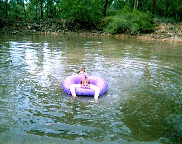
We are concerned that runoff or seepage from the effluent disposal area
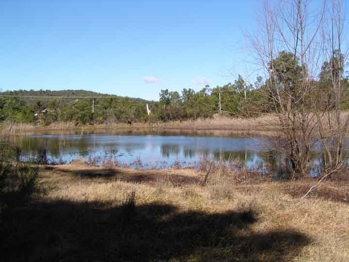
will drain via an existing drainage line to our dam. We use the dam for
swimming and knowing that we will no longer be able to use it in this
way caused us great distress. The assurance that effluent will run off
only 5 percent of the time does not reassure us at all.
Dam that will collect runoff from effluent disposal area
The effluent disposal area and APZ are both shown on plans submitted
with the DA extending onto our property. We do not agree to our land
being used in this way.
Effluent
Disposal
The development application specifies that up to 19,100 litres of
treated effluent will be produced each day. The proposal is to dispose
of this effluent by subsurface irrigation. The calculations that
supposedly show that the 1.5 ha disposal area is sufficient rely on
incorrect and unjustified figures and inappropriate models and contain
arithmetic errors. The development application fails to meet the
requirements of relevant planning documents and guidelines.
Hawkesbury Development Control Plan
Chapter 7 of the Hawkesbury Development Control Plan, states that all
developments relying on an on-site sewage management facility must be
accompanied by a waste water feasibility study. The water feasibility
study must be accompanied by:
site and soil assessment including:
• Proximity to threatened species, populations or ecological
communities or their habitats
Although the site has two threatened ecological communities and at
least three threatened species and their habitats, this is not
acknowledged in the Watercycle Study.
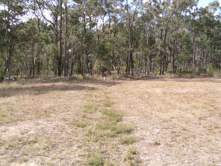
• buffer zones
The Watercycle Study proposes that appropriate buffer zones be provided
but fails to identify that the effluent disposal area is within 100
metres of a watercourse (the creek to the north west) and within 40
metres of a drainage line and dam.
Drainage line leading from the effluent disposal area to a dam on our
property. Both the drainage line and dam are within the buffer zone for
the effluent disposal area. The dam is used for swimming and we are
concerned that we will no longer be able to use it for this.
• proximity to watercourses
The creek to the north west is not shown.
• Soil type including assessment of depth, colour, texture,
permeability, salinity and sodicity, instability, cation exchange
capacity, mobility of nutrients, fertility, Ph and potential to
overcome soil limitations
Although the Watercycle Study provides some assessment of these
factors, in most cases the assessment does not meet the requirements of
On-site Sewage Management for Single Households
(1998) (OSSMSH). Some of the shortcomings of the assessment are:
• Section 3.2 claims 0.6 metres soil depth is adequate but On-site
Sewage Management for Single Households (1998) makes it clear
that the soil depth recommendations of table 6 are based on ideal soil
conditions. No attempt has been made to demonstrate that soil
conditions are ideal and since the claimed depth is only marginally
adequate, this would seem essential.
• Section 3.3 states that “the watertable was not
intersected during bore log investigations” but the
investigations were carried out during a drought when the watertable
drops appreciably. No attempt was made to determine the depth of the
high episodic watertable.
• Section 3.7 reports the pH range of the soil landscapes of
this type but On-site Sewage Management for Single Households
(1998) requires that pH is measured.
• Section 3.8 reports that electrical conductivity was not
measured but measurement is required by On-site Sewage
Management for Single Households (1998).
• Section 3.10 admits that cation exchange capacity is low to
very low. This would indicate that the soils may be unable to hold
nutrients which would lead to runoff of nutrients. Measurement is
required by On-site Sewage Management for Single Households
(1998) unless a detailed survey was undertaken at subdivision stage.
• Section 3.11 points out that the two soil types have
differing phosphorus sorption capacities but On-site Sewage
Management for Single Households (1998) requires measurement
of this unless a detailed survey was undertaken at subdivision stage.
Assessment and Recommendation of Suitable Systems
This is to include methods of disposal and concept design plans of
disposal lines/trenches and full specification.
The layout of subsurface pipework, its spacing or depth is not given.
site plan is to show:
• any existing buildings within 250m of the sewage management
facility or land application area
These are not shown.
• any dams, watercourses, drainage line or pipe work,
vegetation, environmentally sensitive areas within 100 metres of the
sewage management facility or land application area
These are not shown.
Other Problems with the Watercycle Study
Section 2.4 and 2.9 state that “water is to be applied to the
soil only when soil moisture is suitable to receive it” but
does not indicate who will determine this, how it will be determined
and what will be done with wastewater if storage is full and the soil
moisture is not suitable to receive it. In fact the entire plan to
manage wastewater relies on regular and diligent actions requiring
detailed specialist knowledge and monitoring. This is a recipe for
disaster and failure of the system is almost guaranteed. Any lack of
maintenance can result in increased nutrient loading, effluent runoff
or soil degradation.
Calculation at bottom of page 18 states that based on Bacon &
Thompson (1982) the “likely loss from denitrification in
excess of 30% on the first day from surface water application is
likely”. The problems with this model and its assumptions are:
• This figure is for surface application (not subsurface
irrigation). It has been clearly demonstrated that most denitrification
takes place near the surface.
• Refers to loss “on the first day”. To
assume that this rate of loss will be experienced by the entire store
of nitrogen in the soil (as this model does) is unsubstantiated and
ignores the fact that as nitrogen percolates down through the soil the
rate of denitrification will decrease. If you use this model and assume
no added nitrogen beyond the first day (as is normal agricultural
practice where fertiliser is applied only at long intervals) and assume
no uptake by plants but only 15% denitrification each day, after only 5
weeks the soil nitrogen would have decreased to 1/250th of its initial
value. If this were the case fertiliser would have to be added on a
weekly basis. The model just doesn’t work. Environmental
guidelines: Use of effluent by irrigation Department of
Environment and Conservation (NSW) (2004) says of denitrification
“Little information is available on nitrogen loss by
denitrification but it is known to be highly variable and should not be
included in the nitrogen balance unless sound information is available.
Under some conditions denitrification rates will be low which can lead
to excess nitrogen in the system.”.
• Is based on application of fertiliser to agricultural land
where large doses are applied at long intervals. Not to small doses on
a daily basis.
• Is based on agricultural soil where the appropriate bacteria
and necessary organic carbon source could be expected to be present.
Even given the assumption of 15% on the first day, with the rate of
denitrification for each days dose halving each day after it is
applied, say, the model should be:
Ci = Ci-1 - k2
- Nro + Ni - 0.15 x Ni-1
- 0.15/2 x Ni-2 - ...
so since Ni = Ni-1 = Ni-2
etc and summing the series 0.15 + 0.15/2 + 0.15/4 + etc ...
Ci = Ci-1 + Ni
- 3 - 0.3 x Ni
so using 20 mg/L nitrogen in 19000L effluent each day over 1.5 ha we get
Ci = Ci-1 + 174
Although this is a simplification and assumes halving of
denitrification each day after the day of application, this model does
not reach equilibrium but the concentration continues to increase. This
means that nitrogen concentration will continue to increase as long as
effluent is applied. In reality this would result in nitrogen escaping
to the surrounding environment.
Point 2.3 of the Watercycle Study says that wastewater disposal is on
the southeast slope and that this slope is cleared and so has adequate
exposure for irrigation and evaporation. In fact the southeast slope is
the only slope that does not have wastewater disposal. The disposal
area is on the slopes to the east, northeast, north, northwest, west
and southwest all of which are wooded and presumably do not have
adequate exposure.
Section 7.4 of the Watercycle Study says that the disposal area is 3
ha. In fact the disposal area is only 1.5 ha.
Calculations in section 7.4 at the bottom of page 18 assume 25 mg/L
nitrogen concentration, 45000 L/day of effluent and a 4..5 ha disposal
area. These same mysterious figures appear in the related development
application at Lot 201 for a restaurant waste water disposal proposal.
The figures bear no resemblance to either proposal and obviously apply
to some other system. We can only conclude that this report was cobbled
together from another application and that these calculations were
never carried out in relation to this application. This would also
explain the mysterious reference to a 3 ha disposal area in both
applications.
Calculations in section 7.4 at the top of page 19 produce a
concentration of 25 mg/kg of nitrogen in the soil. Using the same
equation on page 19 and the same figures as those assumed here I get
30.5 mg/kg. Even with their figure of 25 mg/kg, the specific needs of
native vegetation which have a lower nitrogen tolerance has not been
addressed.
Table 4 in section 7.2 of the Watercycle Study assumes a nitrogen
concentration in the treated effluent of <20 mg/L but does not
justify this figure. In Environment and Health Protection
Guidelines - On-Site Sewage Management for Single Households
Department of Health et al (1998) and in On-Site Sewage Risk Assessment
System (2001) the expected nitrogen concentration in treated effluent
from an aerated wastewater treatment system is in the range 25 - 50
mg/L. Why the Study chose to use a figure below this minimum is unclear
unless it was chosen to obtain the desired result. OSSMSH also points
out that these figures are usually only achieved when the system is new
and rise thereafter. Using the minimum of 25 mg/L quoted in OSSMSH and
using their formula for calculating the minimum area for disposal
A = C x Q / Ln
where
A is minimum disposal area (m2)
C is concentration of nitrogen in effluent (mg/L)
Q is daily volume of effluent (L)
Ln is critical loading rate for nitrogen (mg/m2/day)
and assuming the typical 25 mg/m2/d critical
loading rate for nitrogen we get
minimum area = 25 x 19000 / 25 = 19000 m2
ie a minimum area of 1.9 ha which is significantly larger than the 1.5
ha allowed for in the application.
Section 7.3 of the Watercycle Study assumes a concentration of
Phosphorus in effluent of 5 mg/L but table 4 in section 7.2 gives the
concentration in the treated effluent as <45 mg/L Consequently
it is not possible to verify the claim that an area of 0.8 ha would be
sufficient for Phosphorus removal. If there are real calculations
showing how this figure can be achieved I would need to see them before
I could comment further. However if we do the calculation using the
expected concentration given in OSSMSH of 10-15 mg/L (I’ll
assume the lowest value of 10 mg/L) we would get twice the area i.e.
1.6 ha which is greater than the area provided. Another problem with
this calculation is that it relies on “amelioration of the
soil” without specifying how amelioration would take place or
how the figure of 0.36g/kg sorption rate would result from the
amelioration. If amelioration involves disturbance of the soil there is
an added risk of erosion and harming the endangered ecological
communities in the effluent disposal area. In fact the calculations for
phosphorus in the Watercycle Study assume that the soil will reach
saturation with respect to phosphorus after 50 years. At the end of 50
years the soil will have to be removed and be replaced. Removal of the
top 40-60cm of soil over an area of 1.5 ha could not be achieved
without destruction of any forest of the endangered ecological
communities that may remain. This short sited approach to conservation
should not be acceptable to Council.
No water analysis is supplied to back the claim that the bore water is
potable. Despite the fact that 5.2.1 of the Watercycle Study states
“water quality shown in Appendix A”, appendix A
only shows the bore results which gives salinity of 250 mg/L Our
experience is that local bore water has an unacceptable amount of
dissolved iron. There are many other possible reasons why the water may
not be potable. No provision has been made to treat the water from the
bore before it is supplied to the cabins.
Although this level of salinity does not prevent the water from being
potable, sodium in the effluent can destroy the soil structure and
interfere with its ability to adsorb nutrients. The Watercylce Study
has not addressed the effect of sodium in the water supply (and
subsequently in the effluent) on the viability of the effluent disposal
area.
The Watercycle Study calls for diversion trenches above the effluent
disposal area but none are shown on the plan (figure 3).
The Watercycle Study concludes that “Environmental impacts
are minimised when the following practices are implemented:
i. Effective separation of the water sources (surface water and
roofwater) ...” but the plan does not have provision for
collecting or diverting roofwater.
The Watercycle Study states that “A detailed Soil and Water
Management Plan should be submitted with the Development
Application.”. This is one of the points where I agree with
the Watercycle Study, however, no such management plan was submitted
with the application.
The Watercycle Study does not address the added risk of nutrient escape
from the effluent disposal area posed by shallow permeable soil over a
rock shelf which is an acknowledged risk factor in land application
disposal schemes.
The Watercycle Study fails to take account of the water repellant
nature of soil in ironbark forests as discussed in Craze and Salmon
(2004) and the effect this would have on the effectiveness of the
effluent disposal area.
Effect of Effluent Disposal on Endangered Ecological
Communities
Chapman and Murphy (1989) describe the Watagan soil landscape as having
low to moderate fertility; the soil materials are strongly acidic and
have low to moderate available water capacities, very low nutrient
status, with low nitrogen and very low phosphorus levels, and low to
moderate cation exchange capacity. The subsoils may have low
permeabilities and pronounced aluminium toxicity.
Chapman and Murphy (1989) describe the Hawkesbury soil landscape as
having very low fertility; the soils are extremely to strongly acidic
with a low to very low nutrient status. The soils are severely
deficient in nitrogen and phosphorus and they have very low cation
exchange capacity. They are also shallow and stony with low available
water capacities and high aluminium toxicity.
This very low nutrient soil has given rise to the endangered ecological
communities found on the site because this is the type of soil they
need. Loading the soil with nitrogen and phosphorus assuming it is an
agricultural crop will prove fatal to the native species that make up
these communities. Both the Watercycle Study and Flora and Fauna Report
fail to address the effect of these nutrients on the endangered
ecological communities.
Threatened
Species and
Endangered
Ecological Communities
The DA does not meet legislative requirements in addressing
the effect on threatened species and endangered ecological communities.
Flora and Fauna Report
Yellow-bellied Glider
The Flora and Fauna Report identifies that the Yellow-bellied Glider is
a Vulnerable Species on Schedule 2 of the NSW Threatened Species
Conservation Act 1995 and that it is found in the development site. The
Report states that “a recovery plan is being prepared for
this species” but in fact a recovery plan was published by
the NSW National Parks and Wildlife Service in February 2003. The NSW
Threatened Species Conservation Act 1995 specifies that any recovery
plan must be taken into consideration but the DA does not consider the
content of this recovery plan.
In the eight part test for the Yellow-bellied Glider:
Part (a) asks “whether the life cycle of
the species is likely to be disrupted such that a viable local
population of the species is likely to be placed at risk of
extinction”. The Report states that the answer is
“No. Yellow-bellied Glider was observed in its den tree
approximately 60m to the West of the boundary of the PDA. The PDA
contains no suitable foraging trees for this species.”
This response is wrong for the following reasons:
• The location 60 m to the west of the PDA places the tree in
the APZ and also in the wastewater disposal zone. The tree is also at
the junction of two existing fire trails. This puts the tree at risk
from:
- subsurface irrigation trenches interfering with its roots,
- subsurface irrigation water causing the soil to become waterlogged
and so loosening the roots’ grip and causing oxygen
deficiency,
- irrigation water increasing nutrients such as nitrogen,
- increased exposure to high winds due to clearing of nearby trees and
- soil compaction around the roots due to increased use of the fire
trails for maintenance tasks.
• The development site contains two species of tree recognised
by the Recovery Plan as sap trees for the Glider. These are the Red
Bloodwood (Corymbia gummifera) and the Grey Gum (Eucalyptus
punctata) both of which appear in the Flora List of the
Report.
• The Glider also feeds on pollen and nectar from the blossoms
of winter flowering gums such as the Narrow Leafed Ironbark (Eucalyptus
crebra) which also appears in the Report’s Flora
List. This type of food source can be critical to population survival.
• The Glider also feeds on insect exudates and these insects
are not limited to known sap or blossom trees. Any decline in the
number of trees will cause a decline in the number of insects available
for this type of feeding.
• A population’s survival is dependent on there
being a variety of food sources that become available at various times
of the year so that any one food source can be critical to the
population’s survival.
• The Recovery Plan states that “Yellow-bellied
Gliders are sensitive to habitat fragmentation through degradation of
existing habitat and creation of dispersal barriers” so that
even if trees are not used as forage trees their removal can restrict
the movement of the Glider effectively cutting it off from parts of its
own home range and isolating the local population causing loss of
genetic diversity.
• The long term viability of a population requires a
succession of trees so that suitable nest trees will be replaced as the
older ones die off. If only current nest trees are considered there is
a real risk that an area will eventually have none.
• The Recovery Plan recognises that thinning of trees can
increase the risk from predation on the Yellow-bellied Glider.
• The Recovery Plan recognises that any fragmentation of
habitat including change in spatial configuration can increase the
effort required to forage resulting in reproductive failure.
Part (c) of the eight part test asks “in
relation to the regional distribution of the habitat of a threatened
species, population or ecological community, whether a significant area
of known habitat is to be modified or removed”. The Report
states that the answer is “No. The area to be cleared does
not contain suitable foraging habitat for this species.”
This response is wrong because there are two sap tree species and a
winter flowering gum species represented in the site as indicated above.
Part (d) of the eight part test asks
“whether an area of known habitat is likely to become
isolated from currently interconnecting or proximate areas of habitat
for a threatened species, population or ecological
community”. The Report states that the answer is
“No. The site has no connectivity value for the
Yellow-bellied Glider”.
This response is wrong because the site is bounded by cleared land to
the west and the river to the south and east. This leaves only the
north as a corridor to other populations of Yellow-bellied Gliders
necessary to maintain genetic diversity. The site creates a northern
barrier to the known home range of the local population.
Part (g) of the eight part test asks
“whether the development or activity proposed if of a class
of development of activity that is recognised as a threatening
process”. The Report states that the answer is
“Yes.” and points out that “Clearing of
native vegetation” (a Key Threatening Process) will be
required for construction. Despite this the Report still concludes that
“No significant effect is anticipated from the proposed
development.”
Given that four parts of the eight part test are positive, a Species
Impact Statement for the Yellow-bellied Glider would seem a minimum
requirement for such a development application.
Other Threatened Species and Ecological Communities
Other Threatened Species and Ecological Communities at this site
include:
Squirrel Glider (although this is not acknowledged in the Report)
Common Bentwing Bat
Eastern Freetail Bat
Shale/Sandstone Transition Forest (SSTF)
Cooks River/Castlereagh Ironbark Forest (CCIF)
Page 27 of the Flora and Fauna Report claims that “The
proposed development is unlikely to have a significant impact on any
Vulnerable Species as none were detected on or adjacent to the
site.” However the Report identifies three Vulnerable Species
on the site.
Insectivorous Bats
The Report admits that for the threatened species of bats, two parts of
the eight part test are positive. Also part (a) admits that foraging
trees will be removed but claims that no roosting habitat exists on the
site. However a recognised threat to the bats is the disruption of the
succession of hollow bearing trees and the proposed clearing will
disrupt this succession. This threat is not addressed.
Shale/Sandstone Transition Forest
In the eight part test the Report states:
Part (c) appears to return a positive result for the eight part test
given the extremely small areas of remaining forest in the area.
Part (f) also returns a positive response.
Parts (g) and (h) both test positive giving 4 of the applicable 6 parts
of the eight part test as positive yet strangely the conclusion is that
“No significant effect is anticipated from the proposed
development”.
It is claimed that only minimal clearing will take place but the
Bushfire Assessment Report specifies that “All of the
achievable asset protection zones must be maintained as
IPA.”. This seems to contradict the assertion of minimal
clearing.
Cooks River/Castlereagh Ironbark Forest
In the eight part test the Report states:
Part (c) appears to return a positive result for the eight part test
given the extremely small areas of remaining forest in the area.
Part (f) also returns a positive response.
Parts (g) and (h) both test positive giving 4 of the applicable 6 parts
of the eight part test as positive yet strangely the conclusion is
again that “No significant effect is anticipated from the
proposed development”.
The Flora and Fauna Report also takes account of potential habitats and
threatened species expected at the site but for the sake of brevity and
due to limited time to respond I have had to leave these out. However
from a quick reading of these sections it appears that there are as
many problems with these as there are with the sections I have covered.
All in all the Report is fatally flawed depending as it does on
spectacularly false information and should not be relied upon in
support of the development application.
Impact Assessment Report for Construction of Boatshed
This Report repeats many of the errors found in the Flora and Fauna
Report including failure to recognise the conservation status of the
two Endangered Ecological Communities in applying the eight part tests.
Consequently this Report should not be relied upon in support of the
development application.
Vegetation Management Plan
The Plan fails to take account of the Wastewater Disposal Area which
will occupy 1.5 ha of the site. The 19000 litres of wastewater that may
be applied to the disposal area each day poses a number of risks to the
Endangered Ecological Communities at the site:
• The wastewater will introduce nutrients for which native
vegetation has reduced tolerance.
• The added water and nutrients will also encourage the spread
of weeds at the site.
• Waterlogging of the soil puts mature trees at increased risk
of falling over and at risk from oxygen depletion in the root zone.
Given the conservation status of the two Endangered Ecological
Communities at the site this oversight is a fatal flaw. Consequently
this plan can not be relied upon in support of the development
application.’
The Watercycle Study also calls for plantings of native species
“most likely to survive when using surface
irrigation” and “which prefer richer conditions,
and therefore more compatible with irrigation areas”.
Presumably the existing vegetation is not “most likely to
survive”, does not “prefer richer
conditions” and therefore is not “more compatible
with irrigation areas”. The plan seems to expect existing
species that make up the endangered ecological communities will die out
and make way for the nutrient tolerant plantings.
Commonwealth
Environmental
Protection and Biodiversity Conservation Act 1999 (EPBC Act)
Under this act it is necessary to obtain an approval from the Federal
Minister for the Environment and Heritage to carry out a
“controlled action”.
“Controlled Actions” include actions likely to have
a significant impact on a matter of national environmental
significance. Matters of national environmental significance include a
listed ”threatened ecological community” such as
the Shale/Sandstone Transition Forest (SSTF) reported at this site by
the Flora and Fauna Report.
Developers have a duty to refer the proposed development to the
Minister for a decision as to whether the proposed action is a
“controlled action” and therefore requires
assessment and approval .
Given that:
• the development application proposes removing many of the
trees that make up this endangered ecological community
• the development application proposes locating a wastewater
disposal area in this endangered ecological community
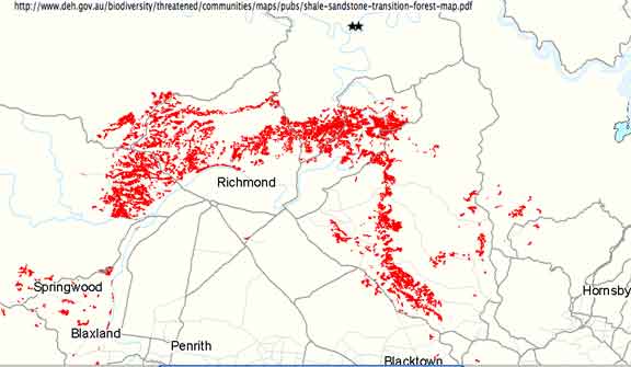
• the EEC is beyond the limit of its known distribution and as
such is recognised as very significant under the EPBC Act as its
destruction would reduce its range
Map showing known distribution of SSTF (red) and SSTF detected at site
(stars)
• the Bushfire Assessment Report specifies that “All
achievable asset protection zones must be maintained as IPA.”
and so extensive clearing will be required throughout the entire SSTF
I would like to request that Council requires that the developer refer
the development to the Federal Minister for Environment and Heritage
for a decision.
International treaties
Under the China Australia Migratory Birds Agreement (CAMBA), Latham's
Snipe (Capella hardwickii) and the Painted Snipe (Rostratula
benghalensis) are listed as migratory species who must be
protected and whose habitat must be protected. Latham’s Snipe
is also listed under the Japan Australia Migratory Birds Agreement
(JAMBA). Both these species are listed in the “Species of
National Environmental Significance Database” as either
occurring in this area or having habitat in this area. The habitat of
both these birds is wetlands and the development site is in the
catchment of both wetlands in the area. Since runoff from the effluent
disposal area drains to both these wetlands it is incumbent on the
developer to assess the impact on these species. The EPBC Act also
defines these species as “a matter of national environmental
significance” and so the developer has a duty to refer this
to the Minister for the Environment and Heritage.
Sydney
Regional
Environmental Plan
No 20 - Hawkesbury-Nepean River (No 2 - 1997) Under the Sydney Regional Environmental Plan No 20 (SREP 20)
Local Councils are the consent authority. As the consent authority the
council must implement the policies and strategies of that plan. These
include the following (shown in italics):
Wetlands
• Protect wetlands (including upland wetlands) from
future development and from the impacts of land use within their
catchments.
• Maintain a variety of wetland flora and fauna species in the
region and consider the scarcity of particular species on a national
basis.
• Encourage the appropriate management of wetlands, including
monitoring and weed control.
• Consider the need to protect and improve the quality and
quantity of surface water and groundwater entering wetlands by
controlling development in the catchment of wetlands.
The development is in the catchment of two mapped wetlands under SREP
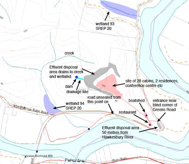
20. One is wetland number 94 on map 15 which is located at the corner
of Wheelbarrow Ridge Rd and Greens Road.
Wetland at the corner of Wheelbarrow Ridge Rd and Greens Rd that is fed
by a creek that collects runoff from the effluent disposal area. The
wetland is mapped wetland no. 94 in the Sydney Regional Environmental
Plan No. 20. Any potential impact on mapped wetlands must be addressed.
This wetland is fed by a creek that runs from north west of the
development and is fed by runoff from the proposed effluent disposal
area and from seepage along the rock shelf that underlies the disposal
area.
Map showing location of wetlands and river in relation to effluent
disposal areas
The other is wetland number 93 on map 15 which is located north of and
down gradient from the site. Since the application does not acknowledge
the wetlands it has not addressed the impact on them. Also the
Watercycle study claims to have calculated nutrient loadings but bases
its calculations on unjustified assumptions, leaves out considerations
recommended by On-Site Wastewater Management Systems for
Single Households (which it claims to have complied with),
uses values in its calculations that bear no resemblance to the
proposed system, contains arithmetic errors and is based on ridiculous
models that appear to be specifically designed to underestimate the
impact of the effluent disposal (see separate section on the Watercycle
Study). The application has not complied with requirements of the SREP
20 in these respects. I cannot see how Council can fulfil its
obligations under SREP 20 in this case.
Clearing
• New development in conservation area sub-catchments should
be located in areas that are already cleared.
• Locate structures where possible in areas which are already
cleared or disturbed instead of clearing or disturbing further land.
So Council has a duty under SREP 20 to encourage new
developments in areas that are already cleared. The most obvious way to
encourage this is to discourage development that requires clearing of
the scale proposed in this development. Flora and Fauna
• Consider the need to provide and manage buffers, adequate
fire radiation zones and building setbacks from significant flora and
fauna habitat areas.
• Consider the need to control access to flora and fauna
habitat areas.
• Minimise adverse environmental impacts, protect existing
habitat and, where appropriate, restore habitat values by the use of
management practices.
• Conserve and, where appropriate, enhance flora and fauna
communities, particularly threatened species, populations and
ecological communities, aquatic habitats, wetland flora, rare flora and
fauna, riverine flora, flora with heritage value, habitats for
indigenous and migratory species of fauna, and existing or potential
fauna corridors.
• Consider the range of flora and fauna inhabiting the site of
the development concerned and the surrounding land, including
threatened species and migratory species, and the impact of the
proposal on the survival of threatened species, populations and
ecological communities, both in the short and longer terms.
The proposed development site has been identified as
containing at least three threatened species and two endangered
ecological communities. Since the Flora and Fauna Report:
- fails to acknowledge the existence of a published Recovery Plan for
the Yellow-bellied Glider (and the developer has a statutory obligation
to take any published recovery plan into account)
- fails to address in any way the effect of effluent disposal on the
two endangered ecological communities (Cooks River/Castlereagh Ironbark
Forest and the Shale/Sandstone Transition Forest) Council is left unable to claim to have complied with the
above policies and strategies of SREP 20.
Aboriginal Heritage
• Protect Aboriginal sites and places of significance.
• Consider an Aboriginal site survey where predictive models
or current knowledge indicate the potential for Aboriginal sites and
the development concerned would involve significant site disturbance.
Since current knowledge indicates that there is a cave containing an
Aboriginal painting on the site (I believe this was reported in the
Gazette in the 1990’s), Council has a duty to instigate an
Aboriginal site survey to determine if the development would involve
significant disturbance.
Effluent Disposal
• Consider the impact on ecological processes, such
as waste assimilation and nutrient cycling.
• The suitability of the site for on-site disposal of effluent
or sludge and the ability of the sewerage systems or works to operate
over the long-term without causing significant adverse effects on
adjoining property.
• The likely effect of any on-site disposal area required by
the proposed development on:
• any water bodies in the vicinity
(including dams, streams and rivers), or
• any mapped wetlands, or
• any groundwater, or
• the floodplain.
• The adequacy of wet weather storage and the wet weather
treatment capacity (if relevant) of the proposed sewerage system or
works.
Unfortunately the Watercycle Study is fatally flawed (see separate
analysis of this). The mapped wetlands are not acknowledged in the
application which also falsely claims to have observed buffer distances
around the effluent disposal area.
No attempt has been made to assess the impact of effluent disposal on
the endangered ecological communities at the site and nutrient loading
standards used are those for agricultural purposes, ignoring the
increased sensitivity of native plants that make up the two endangered
ecological communities.
Again Council is left without the ability to comply with these policies
and strategies.
Hawkesbury River
• Whether the proposed development incorporates
measures to prevent the escape into the waterway of fuels, oils,
grease, anti-fouling chemicals and other chemicals.
The boats housed in the boatshed will no doubt be refuelled and washed
down and any drainage from this site will eventually drain to the
Hawkesbury River. The SREP No. 20 maintains that the definition of a
marina includes any adjoining land used for any support facilities.
Then the Council has an obligation to determine whether the proposed
development incorporates measures to prevent the escape into the
waterway of fuels, oils, grease, anti-fouling chemicals and other
chemicals. In fact the Impact Assessment Report for Construction of a
Boat Shed recommends installation of a high-performance stormwater
pollution trap. The location and details of this engineering solution
has not been shown in this application. This is clearly in breach of
SREP 20.
Land uses in riverine scenic areas
• The need to prevent large scale, high density or
visually intrusive development on waterfront land or on slopes and
ridgetops which are visible from the river or the surrounding visual
catchment. (This requires consideration of the proposed form and siting
of buildings, of the colours and building materials used, and of
landscaping.)
The site is shown on map 15 of the SREP 20 as being of scenic
significance beyond the region (the highest classification of scenic
significance - this also includes it as being of scenic significance in
the region). It is important to note that this requirement is
“to prevent large scale, high density or
visually intrusive development”. It may be possible to
prevent the development from being visually intrusive but it is not
possible to prevent it from being large scale or high density. This is
definitely large scale and high density and will be visible from the
river and surrounding visual catchment. This policy is not observed by
this development. To “prevent” such developments
Council has the power to withhold consent and is bound to exercise this
power.
Conclusion
It is clear from the above analysis that this development application
does not comply with statutory obligations embodied in the Sydney
Regional Environmental Plan No. 20. As consent authority Council is
bound to observe these obligations and so should not grant consent for
this development.
Hawkesbury
Local
Environmental
Plan and Amendment 108
Fails to meet the objectives of zone 7(d)
Zone 7(d) Environmental Protection - Scenic lists among its objectives:
(a) to preserve the existing wooded ridges and escarpments.
(b) to protect hilltops, ridgelines, river valleys and other local
features of
scenic significance by controlling the choice and colour of building
materials and the position of building, access roads and landscaping;
Tree clearing has already commenced at the development site and a few
trees earmarked for retention were marked with a blue ribbon. The
developer indicated to us that trees not so marked would be removed.
This would leave a small number of trees here and there which would
then be vulnerable to dieback that results from clearing and would no
longer be protected by surrounding trees from prevailing winds which
are particularly strong on the mountain top. There is a real risk that
many of the remaining trees would be lost with no way of replacing them
within our lifetimes.
The effect of this clearing is already evident from the surrounding
areas and if the proposed clearing takes place the wooded ridgeline
will be lost.
Further trees will be removed to make way for the cabins, residences,
convention centre, laundry, storage tanks, two swimming pools,
treatment works and parking area. Although not marked on the
development plan all these facilities will have to have access roads
and trees will also have to be removed for these.
The plan submitted with this application is misleading in its depiction
of trees on the site and trees to be removed. The plan only shows a
total of 183 trees in and around the PDA of which 118 are to be
retained while 64 are to be removed. However, in a previous application
for a single dwelling on the same site (DA0622/04) in a letter to
Council dated 6 August 2004 the owner gave a count of “trees
to be removed to open up the canopy as per fire regulations”
of 153 trees greater than 100mm in diameter, 113 of which were greater
than 150mm in diameter. Presumably these 153 trees and more will be
removed “to open up the canopy” in this application
for more than 30 buildings. The trees that will be felled for fire
control are not indicated on the plan. In fact the Bushfire Management
Plan states that all achievable asset protection zones must be
maintained as IPA. This means that almost the entire plateau will be
cleared to IPA standards and more. There are far more trees on the site
than are indicated on the site plan and far more trees will be removed
than those indicated.
One of the “proposed” fire trails has already been
pushed through and several large trees were removed in the process. The
fact that the proposed fire trails go straight through many large trees
that they could go around and that there are already trails running
near and parallel to the proposed ones suggests that the purpose of
these trails is to justify removal of trees so that cabins will have
views of the river.
Fails to meet the objectives of zone Environmental Protection
- Mixed Agriculture
The application is also not consistent with the Draft Hawkesbury Local
Environmental Plan 1989 (Amendment No. 108). Under this draft plan the
development site is to be zoned “Environmental Protection -
Mixed Agriculture” which lists among its objectives:
(e) To promote the conservation and enhancement of local native
vegetation including the habitat of threatened species, populations and
ecological communities by encouraging development to occur in areas
already cleared of vegetation;
With habitat of threatened species and ecological communities
identified at the site Council should encourage this development
“to occur in areas already cleared of vegetation”
by refusing the development application.
(i) To ensure that development does not create unreasonable or economic
demands, or both, for provision or extension of public amenities or
services;
Even if we accept that only 120 trips per day may occur, with half of
these using the Lower Portland Ferry, that is 60 extra vehicles per day
on the ferry. Since some of these should be expected to be towing boats
and with the ferry having a capacity, at most, of 2 or 3 vehicles (1 if
towing a boat), this may amount to 30 extra ferry trips per day. At 10
minutes for the round trip this would involve an extra 5 hours of
operation per day. This would certainly create an unreasonable demand
for this public amenity given that lengthy delays already occur at the
ferry crossing in peak demand periods.
The public boat ramp in Skeleton Rock Reserve would also experience
increased demand during periods when it is already congested.
Clearing
requires
consent of
Minister under the Native Vegetation Act 2003
The forests that make up the two endangered ecological communities
identified at this site are “remnant native
vegetation” under the Native Vegetation Act 2003 and so any
proposed clearing requires consent of the Minister. The Vegetation
Management Plan failed to list this act and did not consider the
implications of this act.
The NVA 2003 defines remnant vegetation in this way:
9 Meanings of remnant native vegetation and regrowth
(1) For the purposes of this Act, remnant native
vegetation means any native vegetation other than
regrowth.
(2) For the purposes of this Act, regrowth
means any native vegetation that has regrown since the earlier of the
following dates:
(a) 1 January 1983 in the case of land
in the Western Division and 1
January 1990 in the case of other land,
(b) the date specified in a property
vegetation plan for the purposes
of this definition (in exceptional circumstances being a date based on
existing rotational farming practices).
(3) In subsection (2) (b), existing rotational
farming practices means rotational farming
practices:
(a) that are reasonable and in
accordance with accepted farming
practice, and
(b) that have been in place since the
date specified in the plan.
(4) Regrowth does not include any native vegetation that has regrown
following unlawful clearing of remnant native vegetation or following
clearing of remnant native vegetation caused by bushfire, flood,
drought or other natural cause.
The native vegetation is either remnant by virtue of the fact that it
already existed in 1990 or by virtue of clause (4) of the definition
above.
Any clearing in relation to the previous development application for
this site (DA0622/04), other than clearing that is “to the
minimum extent necessary for the construction of the
dwelling“ also requires consent of the Minister under this
act and the Draft Native Vegetation Regulation (2004).
Traffic
Risk
Traffic Impact Assessment
Section 2.2.2 of the Traffic Impact Assessment claims that there is
“more than 50 m of available sight distance in each
direction” and that vehicle speeds are low in this section of
road. In fact there is less than 50 m of available sight in each
direction and local residents approaching from the north regularly
drive this section of road at the speed limit which is 80 km/hr.
view from 50m to the south of 4wd wagon
(obscured)
exiting the site access road
view from 50m to the north of 4wd wagon
(obscured)
exiting the site access road
Even if there was 50 m of sight, at these speeds that distance would be
covered in 2.25 seconds and total stopping distance far exceeds 50 m
even on a sealed road. The claim that “the more than 50m
available sight distance in each direction from the access point meets
the requirements of the RTA’s Road Design Guide”
is in fact false. The relevant distance is the Safe Intersection Sight
Distance (SISD) which is given in the Road Design Guide
as follows:
speed (km/hr)
SISD (m)
ASD (m)
40
60
35
50
80
45
60
105
60
70
130
80
80
160
100
The only
way 50m could be considered to meet the requirements would be
to use the inappropriate Approach Sight Distance (ASD) and assume
speeds of no more than 50 km/hr. SISD is clearly the appropriate
distance to use in this situation as it is defined by “This
[SISD] provides sufficient distance for a driver on an approach with
priority to observe a vehicle entering the road, decelerate and stop
prior to a point of conflict.” Using these figures, sight
distances of 160m are more appropriate and 105m could be considered an
absolute minimum. These figures are derived using coefficients of
longitudinal friction based on sealed roads, since friction is much
lower on unsealed roads, sight distances would be significantly longer
than those given. Add to this the fact that the approach from the south
is around a bend and serious accidents would appear inevitable.
The Hawkesbury Development Control Plan specifies at least 70m sight
distance for access to public roads and notes that even greater
distances are required on high speed roads.
This corner is already prone to regular accidents but since the Police
consider this a “no fault” road, few records of
this accident history are available. Given that the cabin occupiers are
expected to be towing boats when they leave the site, the possibility
of accidents is increased even further.
Directly opposite the entrance to the development site is the entrance
to the Hawkesbury Riverside Retreat which has provision for 72 cabins.
During holidays and weekends this section of road has numerous
pedestrians and cyclists from the Retreat and from Una Voce which only
increase the dangers at this point.
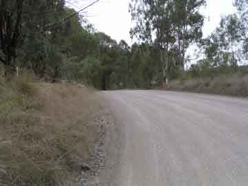
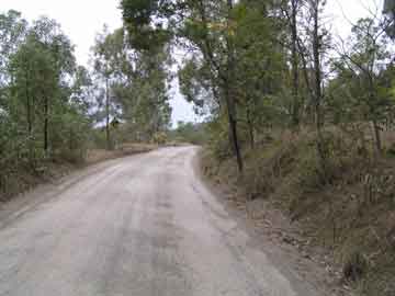
Sections 1.3.2 and 2.2.5 of the Traffic Impact Assessment claims that
there is only 350 m of unsealed road from the site access point. In
fact there is 500 m of unsealed road. It also claims that only 200 m of
this is adjacent to the site and gives the site as Lot 201. In fact the
combined sites of Lot 202 and the related development of Lot 201 front
to the entire 500 m of unsealed road. So even if 200 m of road was
sealed there would still be 300 m of unsealed road (not the 125 m
stated) and all of this would be adjacent to the site.
The Traffic Impact Assessment fails to address the impact of dust on
the river and residents on the other side of the river.
The Traffic Impact Assessment claims that occupiers of the cabins will
stay on site during their stay. This is inconsistent with the provision
of boat sheds and the claim that the tourists will benefit the
Hawkesbury area. Obviously the occupiers, hemmed in between the cabins
and the warning signs on the extensive effluent disposal area, will
venture off site to the surrounding area.
The claim that occupiers will use golf buggies to commute from the top
of the plateau to the restaurant at the foot of the extremely steep
driveway (up to 12.5 degrees or over 22%) provokes scepticism. Death
seems the inevitable outcome of any such foolish attempt. Tung, Hong
and Chan (2000) in Golf Buggy Related Head Injuries
point out the dangers of golf buggies overturning when being driven
down a slope and the subsequent head injuries that can result.
Details
of above objections -
DA0476/05 Change of use to
Restaurant
Effluent
Disposal
Watercycle Study
The Study contains information that indicates there is inadequate water
supply to support the development and that the wastewater disposal area
is inadequate and fails to comply with buffer zone restrictions. The
Study is based on a variety of figures obviously cobbled together using
data from other developments. One is left wondering if the calculations
for this development application were ever carried out. The following
points indicate these shortcomings:
The bore license furnished with this application is to supply water for
Lot 202 only. The license does not allow for supply to Lot 201.
Section 2.4 and 2.9 state that “water is to be applied to the
soil only when soil moisture is suitable to receive it” but
does not indicate who will determine this, how it will be determined
and what will be done with wastewater if storage is full and the soil
moisture is not suitable to receive it.
Section 2.9 proposes buffer zones but Figure 3 shows the disposal area
is within 6 metres of the property boundary. The disposal area is also
only 50 metres from the Hawkesbury River and so there is not a 100
metre buffer to watercourses.
Section 3.2 claims 0.6 metres soil depth is adequate but On-site
Sewage Management for Single Households (1998) makes it clear
that the soil depth recommendations of table 6 are based on ideal soil
conditions. No attempt has been made to demonstrate that soil
conditions are ideal and since the claimed depth is only marginally
adequate, this would seem essential.
Section 3.3 states that “the watertable was not intersected
during bore log investigations” but the investigations were
carried out during a drought when the watertable drops appreciably. No
attempt was made to determine the depth of the high episodic watertable.
Section 3.7 reports the pH range of the soil landscapes of this type
but On-site Sewage Management for Single Households
(1998) requires that pH is measured.
Section 3.8 reports that electrical conductivity was not measured but
measurement is required by On-site Sewage Management for
Single Households (1998).
Section 3.10 admits that cation exchange capacity is low to very low.
This would indicate that the soils may be unable to hold nutrients
which would lead to runoff of nutrients. Measurement is required by On-site
Sewage Management for Single Households (1998) unless a
detailed survey was undertaken at subdivision stage.
Section 3.11 points out that the two soil types have differing
phosphorus sorption capacities but On-site Sewage Management
for Single Households (1998) requires measurement of this
unless a detailed survey was undertaken at subdivision stage.
Section 5.2.3 claims a 1000kL of storage will be provided for fire
protection but plans do not show this.
Section 7 refers to “the significant area available on the
plateau” but the disposal area is located at the bottom of
the site far removed from the plateau. It also claims that
“Figure 6 illustrates the layout of the subsurface
irrigation”. In fact Figure 6 shows a graph of irrigation
area storage requirements. There is no diagram showing the layout of
the subsurface irrigation.
Section 7.3 shows calculations for phosphorus sorption based on 19000
L/day of effluent with phosphorus concentration of 5 mg/L yet table 5
in section 7.2 gives the expected concentration as <15 mg/L and
the effluent volume is 1143 L/day. The calculation gives a result of a
minimal disposal area of 0.8 ha while the proposal is for a 0.1 ha
disposal area.
Section 7.4 shows calculations for nitrogen based on 25 mg/L nitrogen,
45000 L/day of effluent and 4.5 ha application area while table 5 in
section 7.2 gives expected nitrogen concentration of <50 mg/L,
the effluent volume is 1143 L/day and the application area is 0.1 ha.
With the real figures there is a daily input of 568 g/ha rather that
the 247 g/ha claimed.
The calculation for soil concentration where
6.66 x 1000 x 1000 x 25 mg/L /(0.3 x 10000 x 1800 kg/m2)
is claimed to yield 25 mg/kg in fact yields 30.8 mg/kg.
Using the figure for concentration given in table 5 of 50 mg/L and
using the formula for calculating the minimum area for disposal from On-site
Sewage Management for Single Households (1998):
A = C x Q / Ln
where
A is minimum disposal area (m2)
C is concentration of nitrogen in effluent (mg/L)
Q is daily volume of effluent (L)
Ln is critical loading rate for nitrogen (mg/m2/day)
and assuming the typical 25 mg/m2/d critical
loading rate for nitrogen we get
minimum area = 50 x 1143 / 25 = 2285 m2
ie a minimum area of 0.228 ha which is significantly larger than the
0.1 ha allowed for in the application.
Both proposed developments are totally inappropriate for the sites and
should be refused by Council for the reasons outlined above.
In order to comment further on the conclusions of these development
applications I need certain information that was missing or
misrepresented in the applications. Could I please request the
following information to enable me to complete my comments:
DA0439/05
1. Location and extent of effluent disposal area once it no longer
extends onto our property.
2.
Layout, spacing and depth of subsurface irrigation lines.
3.
Nature of soil amelioration proposed and its effect on threatened
ecological communities.
4. How
this amelioration will achieve a phosphorus sorption rate of
0.36g/kg and whether this figure represents the phosphorus sorption
capacity or the achievable sorption rate.
5. Any
calculation using a recognised method of determining the minimum
area required for phosphorus disposal or any calculation based on a
realistic model using verifiable figures and figures consistent with
the proposal.
6. The
plan for remediation of the effluent disposal area when
phosphorus sorption capacity is exceeded and the effect of this
remediation on any remaining endangered ecological communities.
7.
Amount of gypsum to be applied to soil annually and its effect on
threatened ecological communities.
8.
Demonstration that apart from soil depth, other soil factors make
the soil conditions ideal for effluent disposal.
9. The
depth of the high episodic watertable.
10. The
measured pH of the soil in the effluent disposal area.
11. The
measured electrical conductivity of the soil in the effluent
disposal area.
12. The
measured cation exchange capacity of the soil in the effluent
disposal area or the results of any previous detailed survey.
13. The
measured phosphorus sorption capacity of the soil in the
effluent disposal area or the results of any previous detailed survey.
14. A
map showing any existing buildings within 250m of the sewage
management facility or land application area.
15. A
map showing the location of any dams, watercourses, drainage
lines or pipe work, vegetation, environmentally sensitive areas within
100 metres of the sewage management facility or land application area.
16. How
it will be determined when soil moisture is suitable to receive
effluent, who will determine this and what will be done with effluent
when storage is full and the soil moisture is not suitable to receive
it.
17. Any
sound information on expected denitrification rates in effluent
disposal area.
18. Any
calculation using a recognised method of determining the
minimum area required for nitrogen disposal or any calculation based on
a realistic model using verifiable figures and figures consistent with
the proposal.
19. An
assessment of the exposure and potential for evaporation in the
effluent disposal area and any measures required to achieve suitable
exposure and the effect of these measures on endangered ecological
communities.
20. An
assessment of the effects of nitrogen and phosphorus on native
vegetation.
21. A
justification of the claimed expected concentrations of nitrogen
and phosphorus in the treated effluent.
22. How
the expected concentrations of nitrogen and phosphorus will
change over the lifetime of the system.
23.
Water analysis to back the claim that the bore water is potable.
24. The
expected effect of sodium in the bore water on sodium levels in
the treated effluent and the effect of this on soil structure and
ability to accept nutrients.
25. The
location and depth of diversion trenches upslope from the
effluent disposal area and an indication as to where the diverted water
will go.
26. How
roofwater will be kept separated from surface water.
27. A
detailed Soil and Water Management Plan.
28.
Considerations of relevant parts of the Recovery Plan for
Yellow-bellied Gliders.
29. An
indication of the number of trees that will be removed for
construction and maintenance of all the achievable APZ to IPA
conditions.
30.
Details of any plan to ensure a succession of hollow bearing trees
for the threatened species on the site.
31. An
assessment of the effect of the development on nearby wetlands
and migratory birds protected by international treaty.
32. A
plan to ensure that the cave with aboriginal paintings is not
disturbed.
33.
Details of measures to ensure that fuels, oils, grease,
anti-fouling chemicals and other chemicals do not escape into the
Hawkesbury River from the proposed boatshed.
34.
Details of any lawful clearing of native vegetation that has taken
place since 1990 that may justify the claim that the forests consist of
“regrowth”.
35.
Justification of the claim that sight distances at the entrance to
the development are adequate, taking into account the unsealed road
surface and detailing the vehicle speeds along Greens Road used to
calculate the sight distances and why the figure specified in the
Hawkesbury Development Control Plan need not be observed.
DA0476/05
1.
Layout, spacing and depth of subsurface irrigation lines.
2.
Nature of soil amelioration proposed.
3. How
this amelioration will achieve a phosphorus sorption rate of
0.36g/kg and whether this figure represents the phosphorus sorption
capacity or the achievable sorption rate.
4. Any
calculation using a recognised method of determining the minimum
area required for phosphorus disposal or any calculation based on a
realistic model using verifiable figures and figures consistent with
the proposal.
5. The
plan for remediation of the effluent disposal area when
phosphorus sorption capacity is exceeded.
6.
Demonstration that apart from soil depth, other soil factors make
the soil conditions ideal for effluent disposal.
7. The
depth of the high episodic watertable.
8. The
measured pH of the soil in the effluent disposal area.
9. The
measured electrical conductivity of the soil in the effluent
disposal area.
10. The
measured cation exchange capacity of the soil in the effluent
disposal area or the results of any previous detailed survey.
11. The
measured phosphorus sorption capacity of the soil in the
effluent disposal area or the results of any previous detailed survey.
12. A
map showing any existing buildings within 250m of the sewage
management facility or land application area.
13. A
map showing the location of any dams, watercourses, drainage
lines or pipe work, vegetation, environmentally sensitive areas within
100 metres of the sewage management facility or land application area.
14. How
it will be determined when soil moisture is suitable to receive
effluent, who will determine this and what will be done with effluent
when storage is full and the soil moisture is not suitable to receive
it.
15. Any
sound information on expected denitrification rates in effluent
disposal area.
16. Any
calculation using a recognised method of determining the
minimum area required for nitrogen disposal or any calculation based on
a realistic model using verifiable figures and figures consistent with
the proposal.
17. A
justification of the claimed expected concentrations of nitrogen
and phosphorus in the treated effluent.
18. How
the expected concentrations of nitrogen and phosphorus will
change over the lifetime of the system.
19. An
indication of where the water supply will come from given that
the bore licence furnished with the application is not valid for this
site.
20.
Justification of the claim that sight distances at the entrance to
the development are adequate, taking into account the unsealed road
surface and detailing the vehicle speeds along Greens Road used to
calculate the sight distances and why the figure specified in the
Hawkesbury Development Control Plan need not be observed.
Could you please reply to this submission.
I would like to request that I be informed of any changes that are made
to the development applications up until it is decided by Council and I
would like to request the right to comment on any changes that are made.
I would like to request the right to speak at any Council meeting that
decides these development applications.
I would also like to request an appointment to discuss the issues
outlined in this submission. I can be contacted on 45755105.
Yours sincerely
Bill Stern
References
Hawkesbury Local Environmental Plan 1989
Draft Hawkesbury Local Environmental Plan 1989 (Amendment No.
108)
Hawkesbury Development Control Plan
Environmental Planning and Assessment Regulation 2000
Environmental Planning and Assessment Act 1979
Commonwealth Environmental Protection and Biodiversity
Conservation Act 1999
The NSW Threatened Species Conservation Act 1995
Native Vegetation Act 2003
Draft Native Vegetation Regulation 2004
Sydney Regional Environmental Plan No 20
Planning for Bushfire Prevention 2001 (PfBP)
Visual Privacy/Adjoining Neighbours Plan - DA0439/05
Department of Lands Geospatial Portal http://maps.nsw.gov.au/viewer.htm
On-site Sewage Management for Single Households
(1998) (OSSMSH).
On-Site Sewage Risk Assessment System (2001)
Environmental guidelines: Use of effluent by irrigation
Department of Environment and Conservation (NSW) (2004)
Chapman, G.A. and Murphy, C.L. (1989). Soil Landscapes of the
Sydney 1:100,000 Sheet. Soil Conservation Service of NSW,
Sydney.
Craze, B and Salmon, J (2004) A Review of Literature on
Ironbark Ridges and Associated Lands, Department of
Infrastructure, Planning and Natural Resources Temora NSW. China Australia Migratory Birds
Agreement (CAMBA)
Japan Australia Migratory Birds Agreement (JAMBA)
M Y Y Tung, A Hong, C Chan (2000) Golf Buggy Related Head
Injuries Singapore Med J 2000 Vol 41(10) : 504-505